
These are the routes we rotate on Tuesdays from University Park
Each ride is planned as 30 miles
with a 25* mile shortcut version.
Click HERE for the upcoming Tuesday schedule
Click the NAME to get Route Slip as a printable .pdf
L & R are obvious turns, *L suggests using a 2 stage box turn, °L lets you know it is circle left, around most of a round-a-bout, but there are some other obscure codes also found on them - see the route slip cue glossary HERE.
Some lines are color tinted:
Light Blue means it’s a sidewalk or side path along a street.
Pink means it is on a bike path or shared use path off street.
Green means it is a separated class 4 cycle track.
Yellow if used means an unpaved section.
(Date is of current version created or updated)
Description is the coffee stop regroup point
## miles (## to regroup) +### elevation {CF # ##.# ’/m is Average elevation per mile}
TUESDAY ROUTES CLIMB FACTORS (Feb 2026)
Click the link to see RideWithGPS for a map with elevation profile or to run the RideWithGPS App on your phone other device &/or upload the file to your GPS device.

Note - RideWithGPS does provide a rough full page Cuesheet for each route, but the BCI Route Slip is most accurate and will fit on 1/2 page slip… Each route slip has 2 pages: One for the full 30ish and one for the 25ish ‘short cut’. Print the page you want to ride (or both) and fold. Some include a page or two of details of the tricky parts. Print at your option…
Some bits are tricky; for places where it would be easy to get lost, there are
> Detail of Mile X / X mini maps being posted. Miles on those mini maps refer to the route slip turns.
ROADS CHANGE - THESE ROUTES MAY BE OUTDATED IF NOT RECENTLY POSTED and we can’t guarantee the route is still undisturbed by road work or new options, and we can’t assume any responsibility if you choose to follow any of them as a club ride or on your own, and the Members’ supplemental insurance does not cover you if you ride these when not scheduled by the club.
Please report any link, route or map errors to Rides@BikeIrvine.org

ROUTE SLIPS: Tu01 Lake Forest: Trabuco & Bake (4/1/26)
Starbucks / McDonalds @ Irvine/Trabuco & Bake in Lake Forest
30.2 miles (19.9) +972 ft {CF 3 32.2’/m}
https://ridewithgps.com/routes/26599732
> Detail: Mile 20.1-21.8 (full 30)
25.0* miles (15.1) +577 ft {CF 2 23.9’/m}
https://ridewithgps.com/routes/26599780
(skips Tustin Ranch, Orchard Hills & Portola)
ROUTE SLIPS: Tu02 Newport Beach: Bison & MacArthur (4/2/26)
Mag’s Donuts / Starbucks on Bison between MacArthur & Camelback in Newport
29.9 miles (19.4) +1,212 ft {CF 4 40.5 ’/m}
https://ridewithgps.com/routes/35427519
> Detail: Mile 19.5-19.9 (full 30)
25.2* miles (19.4) +991 ft {CF 3 39.3 ’/m}
http://ridewithgps.com/routes/35427345
(skips MacArthur, San Joaquin and Back Bay on return)
> Detail: Mile 19.5-21.3* (short cut)
> DETOUR TODAY:
The connector from the San Diego Creek Trail to EB Michelson is closed.
EXIT the San Diego Creek Trail and CAREFULLY make a left onto HARVARD NB at mile 28.2 on the 30 mile route and mile 23.5 on the 25 mile short cut route today.
ROUTE SLIPS: Tu03 Foothill Ranch via the Borrego Trail (4/7/26)
Bodhi Leaf @ Lake Forest & Rancho Parkway in Lake Forest
30.4 miles (17.8) +1,273 ft {CF 4 41.9’/m}
https://ridewithgps.com/routes/23564296
25.1* miles (12.4) +958 ft {CF 3 38.2’/m}
https://ridewithgps.com/routes/21690273
(Skips Culver, Portola, Modjeska, Irvine Blvd )
> Detail: Mile 14.9-16 / 9.6-10.7* (BOTH)
ROUTE SLIPS: Tu04 Newport Coast via Laguna Beach (3/9/26)
Blk Dot (formerly Starbucks) @ Crystal Cove Center in Newport Coast
30.4 miles (15.8) +1,177 ft {CF 3 38.8’/m}
http://ridewithgps.com/routes/11728527
> Detail: Mile 12.0-12.3 (full 30)
25.4* miles (10.6) +964 ft {CF 3 38.0’/m}
https://ridewithgps.com/routes/18677499
(Skips Laguna Canyon & Laguna Beach)
> DETOUR TODAY:
The connector from the San Diego Creek Trail to EB Michelson is closed.
EXIT the San Diego Creek Trail and CAREFULLY make a left onto HARVARD NB at mile 28.6 on the 30 mile route and 23.6 on the 25 mile short cut route today.
ROUTE SLIPS: Tu05 Foothill Ranch: Alton & Rancho Pkwy (3/9/25)
Starbucks @ Alton & Rancho Parkway in Lake Forest
30 miles (14.8) +1,199 ft {CF 4 40.0’/m}
https://ridewithgps.com/routes/29319880
25* Miles (10.4) +988 ft {CF 3 39.5’/m}
https://ridewithgps.com/routes/29319758
(skips Yale, Hicks Canyon, Portola, Portola Springs, Modjeska, Irvine Blvd on way up
& Antibes, Paloma & Portola on return)
> Detail: Mile 14.8-17 / 10.3-12.2* (BOTH)
ROUTE SLIPS: Tu06 Corona del Mar (3/17/26)
Starbucks or Bruegger’s @ PCH & Goldenrod in Newport Beach
30.1 miles (16.4) +1,645 ft {CF 5 54.7 ’/m}
https://ridewithgps.com/routes/14751662
Heads out University to Newport Beach, up Spyglass then down Newport Coast into the cool air onto PCH to CDM; After coffee it rolls up Back Bay Drive, and up Mesa/Birch to Von Karman then back East on Michelson.
25.1* miles (11.1) +934 ft {CF 3 37.2’/m}
https://ridewithgps.com/routes/11728676
Skips the climb over Spy Glass, San Joaquin Hills & Newport Coast, dropping sooner into CDM on Marguerite from the top at Bayview.

Heat Wave Alternate:
On really hot days, TU06 is offered as an alternate choice, heading toward the coast and closer to the beach. If the scheduled rotation ride heads inland into the heat, members might want to ride this alternate, (or leave early before the regular start, or stay off the road or do their own ride… )
ROUTE SLIPS: Tu07 Lake Forest (3/31/26)
Bagels & Brew @ Lake Forest & Serrano in Lake Forest
30.3 miles (20.1) +1,413 ft {CF 4 46.6 ’/m}
https://ridewithgps.com/routes/26548094
> Detail: Mile 14.4-15.2 (full 30)
25.3* miles (15.2) +1,007 ft {CF 3 39.8 ’/m}
https://ridewithgps.com/routes/21690275
(Skips upper Bake, Glenn Ranch & Aliso Creek Trail)
ROUTE SLIPS: Tu08 Irvine: Woodbury (3/24/26)
Starbucks & Panera Bread @ Sand Canyon & Irvine Blvd in Irvine
30.1 miles (18.4) +1,159 ft {CF 3 38.6 ’/m}
https://ridewithgps.com/routes/24710673
> Detail: Mile 18.7-19.9 (full 30)
24.9* miles (16.2) +976 ft {CF 3 39.2 ’/m}
https://ridewithgps.com/routes/21690286
(Skips a bit of the Great Park, and mazes in Northwood)
ROUTE SLIPS: Tu09 Newport Beach: Fashion Island (3/31/26)
Starbucks @ Fashion Island in Newport Beach
30.3 miles (20.3) +1,072 ft {CF 3 35.4 ’/m}
https://ridewithgps.com/routes/33937063
25.5* miles (17) +917 ft {CF 3 36.0 ’/m}
https://ridewithgps.com/routes/11729889
(Skips Quail Hill & Laguna Canyon)
> Detail: Mile 20.2-20.6 / 16.9-17.3* (BOTH)
> DETOUR TODAY:
The connector from the San Diego Creek Trail to EB Michelson is closed.
EXIT the San Diego Creek Trail and CAREFULLY make a left onto HARVARD NB at mile 28.6 on the 30 mile route and mile 23.7 on the 25* mile short cut today.
ROUTE SLIPS: Tu10 Mission Viejo (4/7/26)
Einstein Bros. @ RSM Pkwy & Los Alisos in Mission Viejo
30.1 miles (14.1) +1,103 ft {CF 3 36.6 ’/m}
https://ridewithgps.com/routes/29519515
26.7* miles (13.2) +1,071 ft {CF 4 40.1 ’/m}
https://ridewithgps.com/routes/21690290
(Skips climb up Serrano, Marguerite & some of
Los Alisos/Muirlands/Barranca, ICD & West Yale Loop on return)
> Detail: Mile 12.6-14.4 (BOTH)
ROUTE SLIPS: Tu11 Newport Coast : Crystal Cove (4/1/26)
Crystal Cove Shake Shack on PCH in Newport Coast
30 miles (15.6) +1,036 ft {CF 3 34.5 ’/m}
http://ridewithgps.com/routes/11629804
25* miles (11.6) +934 ft {CF 3 37.4 ’/m}
https://ridewithgps.com/routes/21690293
(Skips Michelson, Von Karman, Dove, Birch, Orchard, Orchid, Bayside, Mesa, Bayview Trail & Larkspur/Seaview and Michelson on return)
DETOUR TODAY:
The connector from the San Diego Creek Trail to EB Michelson is closed.
EXIT the San Diego Creek Trail and CAREFULLY make a left onto HARVARD NB at mile 28.3 on the 30 mile route today.
ROUTE SLIPS: Tu12 Irvine: Orchard Park (4/20/26)
Peet's @ Culver & Portola in Irvine
30 miles (17.7) +1,102 ft {CF 3 37.7 ’/m}
http://ridewithgps.com/routes/11629991
25.7* miles (16.4) +837 ft {CF 3 32.6 ’/m}
https://ridewithgps.com/routes/25612901
(Skips Tustin Ranch / Von Karman to Michelson)
> DETOUR TODAY:
The connector from the San Diego Creek Trail to EB Michelson is closed.
EXIT the San Diego Creek Trail and CAREFULLY make a left onto HARVARD NB at mile 24.1 on the 25 mile short cut route today.
ROUTE SLIPS: Tu13 Irvine: Los Olivos (4/28/26)
Starbucks @ Research & ICD in Irvine
30.1 miles (15.9) +1,251 ft {CF 4 41.6 ’/m}
https://ridewithgps.com/routes/25901514
24.9* miles (10.6) +640 ft {CF 2 25.7 ’/m}
https://ridewithgps.com/routes/25902494
(Skip climbs up Ridgeline & Santa Vittoria)
> Detail: Mile 4.5-5.6* (short cut)
> Detail: Mile 9.9 / 7.1* (BOTH)
> DETOUR TODAY:
The connector from the San Diego Creek Trail to EB Michelson is closed.
EXIT the San Diego Creek Trail and CAREFULLY make a left onto HARVARD NB at mile 28.5 on the 30 mile route today.
ROUTE SLIPS: Tu14 Tustin (5/9/26)
Kéan Coffee @ Main & Newport in Tustin
30.1 miles (14.7) +525 ft {CF 1 17.4 ’/m}
https://ridewithgps.com/routes/38475693
> Detail: Mile 16-16.2 (full 30)
> Detail: Mile 16-17 (full 30)
25.1* miles (15) +378 ft {CF 1 15.1 ’/m}
https://ridewithgps.com/routes/38475705
(skips Cowan Heights / North Tustin segment)
> Detail: Mile 2.4-4.0 (BOTH)
> Detail: Mile 11.5-16.0 (BOTH)
> DETAIL: All 4 detail maps in one pdf
ROUTE SLIPS: Tu15 Irvine: Hoag (5/9/26)
W Café @ Sand Canyon & Hoag Hospital in Irvine
29.9 miles (18.8) +1,062 ft {CF 3 35.5 ’/m}
https://ridewithgps.com/routes/32000419
25* miles (15.8) +807 ft {CF 3 32.2 ’/m}
https://ridewithgps.com/routes/32000405
(skips Walnut & Tustin Ranch, Orchard Hills on way out,
and Antivo/Research & Scientific and Knowlcrest & Quail Ridge on return)
> DETAIL: MILE 16.4 / 13.4* (BOTH)
> DETAIL: MILE 19.8-20.5* (short cut)
> DETAIL: MILE 26-27 / 22.-22.3* (BOTH)
ROUTE SLIPS: Tu16 Orange (5/10/26)
Tru Bru Organic Coffee @ Newport & Chapman in Orange
31.3 miles (13.1) +1,406 ft {CF 4 44.9 ’/m}
https://ridewithgps.com/routes/32694397
> Detail of Mile 13-15.5 (full 30)
26.2* miles (13.1) +1,168 ft {CF 4 44.6 ’/m}
https://ridewithgps.com/routes/32694235
(skips Orange Park Acres horse country and Emus, Climb over Cannon, Crawford Canyon, Barrett - Cowan Heights / North Tustin segment)
> DETOUR TODAY:
The connector from the San Diego Creek Trail to EB Michelson is closed.
EXIT the San Diego Creek Trail and CAREFULLY make a left onto HARVARD NB at mile 29.9 on the 30 mile route and 24.8 on the 25 mile short cut route today.
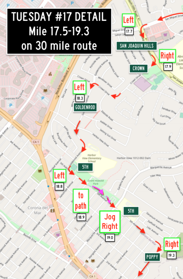
ROUTE SLIPS: Tu17 Newport Beach: Ford & San Miguel (5/10/26)
Chaupain Bakery / Pavilions Starbucks @ Ford & San Miguel in Newport
30.2 miles (16.1) +1,649 ft {CF 5 54.6 ’/m}
https://ridewithgps.com/routes/32052744
> Detail: Mile 3.5-4.8 (full 30)
> Detail: Mile 17 - 19.3 (full 30)
24.9* miles (13.1) +1,182 ft {CF 4 47.5 ’/m}
https://ridewithgps.com/routes/32052482
(skips Ridgeline & Corona del Mar)
> Detail: Mile 0.0-2.8* (short cut)
> Detail: Mile 16-16.3 / 13.0-13.3* (BOTH)
ROUTE SLIPS: Tu18 Costa Mesa (5/10/26)
including Santa Ana River Trail to
French’s / Starbucks @ Baker & Fairview in Costa Mesa
30.1 miles (17.4) +493 ft {CF 1 16.4 ’/m}
https://ridewithgps.com/routes/37968276
> Detail: Mile 17.4-17.7 (full 30)
25* miles (14.7) +364 ft {CF 1 14.6 ’/m}
https://ridewithgps.com/routes/37968243
(Skips PCH out & Victoria, Warner, Tustin Ranch on return)
> Detail: Mile 6.9-11.5* (short cut)
> Detail: Mile 14.5-15.5* (short cut)
ROUTE SLIPS: Tu19 Huntington Beach (5/15/26)
Starbucks @ Goldenwest & Yorktown in Huntington Beach
30.2 miles (16.5) +576 ft {CF 1 19.1’/m}
https://ridewithgps.com/routes/41300931
> Detail: Mile 19-20 (full 30)
> Detail: Mile 21-22 (full 30)
> Detail: Mile 23-24 (full 30)
26.8* miles (13) +555 ft {CF 2 20.7 ’/m}
https://ridewithgps.com/routes/41300981
(Skips PCH out & takes upper bay trails on return)
> Detail: Mile 5-7 & 16-21* (short cut)
> Detail: Mile 7-8 & 17-19* (short cut)
ROUTE SLIPS: Tu20 Orange via Santa Ana (5/15/26)
including the Flower & Pacific Electric bike paths, North Flower district to the
Coffee Bean & Tea Leaf / Corner Bakery @ Main & Memory Lane in Orange
30.1 miles (14.3) +392 ft {CF 1 13.0 ’/m}
https://ridewithgps.com/routes/41570341
24.9* miles (12.5) +312 ft {CF 1 12.5 ’/m}
https://ridewithgps.com/routes/47085618
(Skips 3.6 miles across Tustin on return)
> Detail: Mile 4.8-7 (both) Sunflower to Pacific Electric Trail
Note - Route Tu20 is not a typical Tuesday BCI Ride - LOTS of turns and city streets…
Most have enjoyed it but there WILL be others who will opt to skip this one and ride ROUTE SLIPS: Tu13 Irvine: Los Olivos instead, so print / load both if you want the option at 9:15!
30: https://ridewithgps.com/routes/48481120
25: https://ridewithgps.com/routes/48481334
> DETOUR TODAY:
The connector from the San Diego Creek Trail to EB Michelson is closed.
EXIT the San Diego Creek Trail and CAREFULLY make a left onto HARVARD NB at mile 23.3 on the 25 mile short cut route today.
ROUTE SLIPS: Tu21 Irvine (5/10/26)
The Olive Grove Café on Burt/Progress, west of Sand Canyon
30.0 miles (14.9) +713 ft {CF 2 23.8’/m}
https://ridewithgps.com/routes/41602018
> Detail: Mile 17.1-21.5 (full 30)
25.0* miles (14.9) +523 ft {CF 2 20.9 ’/m}
https://ridewithgps.com/routes/41602046
(Skips some of Spectrum, Bake, Lake Forest and Laguna Canyon on return)
> Detail: Mile 10-17 (BOTH)
• CyclingSavvy Tips for Route 21: The full route takes Bake across the 405 freeway...
All though Bake is a Class II bikeway, Irvine and Caltrans have failed to mark any of their own Complete Streets tools, and allows both right lanes to enter the freeway at two high speed entrances. Mile 19.9 to 20.4 can be a stressful 1/2 mile.
Even though posted at 50 MPH, motorists speed on Bake, and they accelerate as they merge into the high speed entrances, making it critical for cyclists to assert their lane position early to be seen and safely cross the freeway.
You can’t signal and hope to be let over, you need to time your merge and be assertive.
Marine Way to Bake: @Mile 19.4
This is a perfect place to use the Right on Green CyclingSavvy tip: Stop on the red and WAIT until the green light - Bake traffic will be held with a red light and give you at least a head start on the road. It’s a long light and few motorists will come up behind you.
• Pause on Marine Way to regroup; several cyclists together riding double file have an advantage to be seen and control any lane. Pausing also lets you time the signal so you can get the red light at the corner of Bake. Ride double file & control the #2 lane to the CORNER. Wait for the green light - which stops ALL traffic coming on Bake behind you as you turn right. Swing out to the #2 lane & ride it double file. Stay in the #3 lane to avoid the #4 RTOL freeway entrances to the 5/405 NB.
There is no room to ride the gutter & share the #4 or #3 lane with passing vehicles, most of which will be speeding onto the freeway.
If you don’t feel safe using the street, onto the sidewalk, but use extreme caution at crosswalks to get across DOUBLE FREEWAY ENTRANCE LANES.
Bake to I-5/405 NB entrance: Mile 19.9
• If you are already controlling the #3 lane, motorists heading for the freeway will pass on the right in #4 RTOL. Those going straight can merge and pass you in the #1 or #2 lanes on your left.
• If you ride in the bike lane, it ends at the second double entrance so you will have speeding motorist passing and entering the freeway across you from the #3 combo lane and the #4 RTOL, You may not be unable to merge over to control the #3 lane at that point when the bike lane ends. If you are stuck in the bike lane, just stay right and use the shoulder or sidewalk along the entrance, all the way to the crosswalk.
• Watch out at the crosswalk. If one lane stops for you the second lane may not.
Controlling the #3 combo lane really is safest.
BAKE to I-5/405 SB entrance: Mile 20.4
• There is an unmarked bike lane over the bridge, but just control the #3 combo lane as early as possible, well before the bike lane ends for a RTOL.
• If you make it to the shoulder after the bike lane ends or ride the sidewalk, watch out at the crosswalk. If one lane stops for you the second lane may not.
• Past the exit, everyone can enjoy the bike lane again at mile 20.4.


