Laguna Canyon Road: 73 Toll Road to El Toro Road

Laguna Canyon Road (SR133) is being made wider to provide a shoulder for us, but during construction, the road has been narrowed to 2 narrow lanes. There is no shoulder on the uphill - inland side, and downhill toward Laguna there is a narrow shoulder stripped right up along the concrete K-Rails).
Vehicle traffic can always get ugly on the ‘Canyon’ so if you are in the travel lane with bumper to bumper traffic, CONTROL your lane, and expect motorists to tailgate you. Don’t move to the edge and invite a close passing risk, or try to pass on the right. It is only a bit over 1/2 mile until the wider shoulder resumes to ride in. Despite “SHARE THE ROAD” signs posted;
If traffic is light, expect motorists to come up at freeway speeds behind you…

Going downhill it is easier to pick up speed and merge into the travel lane BEHIND the platoon of tailgating motorists, if you time the light at the 73. Some hold up at the signal UNTIL the traffic gets stopped with red light, and then have the whole stretch to take the travel lane.
Stay in the travel lane and you will be most visible and consequential to the next platoon when it gets the green light at the 73. Control and release the lane only when safe for you to do so. Once you control the first motorists, the rest will be held up behind.

It will be a bit slower and longer timewise climbing uphill, but even more important where there is no shoulder. Riding the edge invites unsafe passing, so control your lane until safe for you to ride the shoulder again.

If you go between Laguna and Irvine, expect this 1/2 mile pinch points and use extreme caution or choose the longer way around the 'canyon' on El Toro Road (only adds 2.5 miles to avoid the 0.6 mile project zone).
SB Detour: https://ridewithgps.com/routes/34389510
NB Detour: https://ridewithgps.com/routes/34389593

This detour may or may not have been posted by Caltrans.

NB: Take El Toro Road all the way to Moulton, turn west to Lake Forest and take Lake Forest back west to the Romano/Pavona sidewalk. (or Stay on El Toro & turn North on Laguna Canyon.
Instead of the 4.1 miles and 232 feet of climb from El Toro to Lake Forest on the shoulder of the 133 Laguna Canyon Highway, the detour takes you 6.7 miles and climbs 451 feet. (Add 2.6 miles and 219 feet of climb)
Until the road work is completed - BCI will SKIP Routes #25 & #26 that go this way…

SB: Take the Pavona/Romano sidewalks to Lake Forest, (or turn left from Laguna Canyon East onto Lake Forest); Go right on Moulton, and then right on El Toro Road all the way to Laguna Canyon, past the pinch point.
Until the road work is completed - BCI will SKIP Route #25 and offer detours on #18, #26, and Tuesday #04.

Did we metion, it may take 2 years before the work is completed, utilities are put in, and the improved road is restriped and this concern will be over…

Pointz - like Waze for Cycling

My name is Maggie -- I am reaching out to share Pointz, a safety-focused mapping app for bike, e-bike, and e-scooter riders!

We’re doing a push to find safer bike routes in Irvine and would love to partner with BCI members to get the word out. Our goal is to get as many safety ratings in the app as we can.

If it's of interest, we'd also love to help with digitizing any maps you already have by adding them to Pointz. Let me know what you think! :)

Best,
Maggie Bachenberg
maggie@bikepointz.com

SART at Green River

We rode the Riverside to Anaheim Canyon “Turkey Burner” today, November 26th, and found some interesting stuff on Green River at the upper end of OC’s section of the Santa Ana River Trail bikeway.
They are widening the WB 91 freeway (AGAIN). The trailhead parking area is closed; teh gate where teh SART drops onto the cul de sac of Green River is closed, but bikeway access is open from the sidewalk corner curb cut along the parking stalls.

Up the road, Green River Road along the 91 freeway is reduced to a stretch of one lane road, with red lights controlling when traffic flows up or down, and there is a 2 way un separated bikeway painted on the south east side of green river adjacent to the freeway construction work to give us an option of staying of the one travel lane…

Watch for Steel Plates in the Road

W8-24 Steel Plate Ahead  copy.gif

Von Karman is getting a great repavement job currently and the new asphalt is smooth - but there are still some areas being worked on. Watch out for steel plates. The edges are not always properly ramped to get onto them so the hard steel edge can give you a pinch flat, a bit of traffic film, sand or morning dew can make them slick, as a member found when she slipped and crashed on one a while back, and if they are in place a while, heavy vehicle traffic can make them shift, especially at a corner. Once placed, they are usually packed in with some ‘cold patch’ asphalt to hold them in place, but if left for a long time with heavy traffic, or not packed in well they will shift. Last Saturday a gap was noticed on SB Von Karman @ Campus, right in the middle of the #2 lane where cyclists would ride. Circled back and staged how bad a bicycle would fall into the gap, the situation was called in to Irvine PD who would send out an officer to verify, then call out the Public Works - Streets employee on call to cone off the #2 lane until the steel plates can be repositioned.
If you see something - say something. IPD Dispatch is (949) 724-7206 and they have city staff on-call to address problems on weekends if you report them.

No one was injured in the staging of this bike…

No one was injured in the staging of this bike…

If you cc an email to OCBC they will also follow up with the right people to get it fixed ASAP. infrastructure@ocbike.org

If you cc an email to OCBC they will also follow up with the right people to get it fixed ASAP.
infrastructure@ocbike.org

Regional Parks Connector Bikeway - North of Edinger under the Railroad Tracks

April 19 2023 update - Still officially CLOSED and gates LOCKED:
After the Tustin segments were completed 2021, we would expect to enjoy this bike path but no.
Rolling Upstream the “BIKE LANE CLOSED” sign (this is a path not a bike lane) was tossed into the creek, so people continued to ride under the closed underpass twice; to the back side of the upstream locked gate, then back under again to take the Walnut Trail east to Harvard… when it was available. The County has chained the new detour sign to the post and added a screened fence, and now a locked gate to stop access from downstream.

Rolling Downstream the County has posted an informational sign on the locked gate at least explaining WHY & who to contact about it… a similar sign has also been posted on the downstream approach. Despite this - vandals have actually cut out a section of chain link to access the undercrossing.

The Regional Parks Connector Bikeway is now completed from Peters Canyon Regional Park all the way to the Upper Newport Bay. (AKA “Mountains to the Sea” and “Peters Canyon Trail” )
The newest segment was completed between Warner and the railroad crossing in the City of Tustin. With grade separation added under Moffet and Edinger, new LED bollard lighting & smooth asphalt, 2 foot clear zones outside edge lines, it is an outstanding Class I bikeway - but still a shared-use path, not just for cyclists.
The remaining missing segment now is on the Irvine / Tustin city limit; across the Como channel & under the railroad tracks - between the Walnut path (Tustin) and Como Channel path (Irvine).
OC Parks is still trying to get approval from the California Public Utilities Commision for public access under the tracks.
OC Parks Santa Ana River Trail crosses the OC Streetcar and train bridges in Sanat Ana , Anaheim and Orange. The Santiago Creek Trail passes under the tracks between Glassel & Memory Lane. The Aliso Creek Trail crosses under the train bridge between Muirlands and Jeronimo. The San Juan Creek Trail passes under the tracks in San Juan Capistrano.
Why is this one stalled? No one seems to know.
There is actually no idea of when it might get approved.

Until then, the gate at the north side (upstream) of the tracks is to remain locked. That gate eventually needs to be removed, replaced with one that will swing back against the fence out of the path, but that could be delayed until after approval and the paint & signs & railing or flexi-delineators are be completed under the tracks. There was no gate downstream, so fencing was been placed to keep people from using the path under the tracks. Now a new gate has been installed there as well - and locked.

OCBC’s suggestions to OCTA / OC Parks to stripe & sign the path under their tracks.

OCBC’s suggestions to OCTA / OC Parks to stripe & sign the path under their tracks.

Legally you should detour and NOT go over/around/through the gate or under the tracks. The County has not removed their regulatory “MAINTENANCE VEHICLES ONLY” or “NO TRESPASSING” signs. Until opened some day, you are trespassing.

BCI looks forward to adding the path to rides once this segment is officially open.
We will update this info when OC Parks gets the underpass approved by the CPUC, the lines get painted and the locked gate is removed or replaced. Know it will take a long time.

This is the closed and un-striped underpass. OC Parks won’t paint or sign it until approved.

This is the closed and un-striped underpass from downstream. The support in the pathway needs some marking & signage but OC Parks won’t improve it until approved by the CPUC.

Tustin’s segment of the “Walnut Trail’ path (actually private, not City or County path) was delayed by IRWD work but was open as of July 14, 2021. Below is OCBC’s map of what the short detour looks like:

OC Parks will not post this detour for the intended users of the Regional Parks Bikeway.

OC Parks will not post this detour for the intended users of the Regional Parks Bikeway. The path was never officially open and the Walnut Trail segment is on private property.
Upstream you should use the sidewalk - do not ‘salmon ride’ on this or any Bike Lane.

Southbound at the locked gate, turn east on the Como Channel Class I path to Harvard Avenue. The City of Irvine has posted a sign advising to do so. Take the SB Harvard Avenue Class II Bike Lane across the channel & railroad tracks to the Walnut Class I path; go west back to continue on the Class I path SB (downstream) under Edinger.

Northbound from Edinger, exit the path before the underpass below the tracks onto the Walnut Class I path east to Harvard. Take the sidewalk (DO NOT RIDE WRONG WAY IN BIKE LANES!) across the tracks & channel to the Como Channel Class I path; go west back to continue on the Class I path NB (upstream stream) past Harvard Athletic Park and under Walnut.

This segment of the “Walnut Trail” is IN the City of Tustin but is privately owned and has not been well maintained by the Tustin Fields neighborhood. They have never responded to repeated contact from OCBC and the City of Tustin got on them with code enforcement. ‬The worst 40’ long crack caused a broken arm crash on July 31st and was DIY ‘tagged’ with spray paint. Eventually the worst of the cracks were filled, but slow down through this narrow bad stretch of now very busy shared use path.

For sharing your concerns - please contact OC Parks (949) 923-3716‬
Regional Bikeway Corridors:
Peter Sotherland at OCTA (714) 560-5386‬

Regional Parks Connector Bikeway DETOUR until August 27 - extended ‘til September 24…now open.(Resolved)

Between Michelson and Campus the Regional Parks Connector Bikeway (AKA Mountains to the Sea , San Diego Creek & Peters Canyon) has a hard closure and detour on sidewalks. The IRWD is working on 2 sewer syphons that go under the channel.

Just at the T intersection with the connector of the Sand Canyon bikeway, the trail is closed heading upstream and the detour sends you abruptly east, across a driveway, to the NW corner of Harvard & University - then north on the sidewalk of Harvard across 2 more driveways to just past the construction zone. It is illegal and dangerous to ride the wrong way (facing traffic) in bike lanes (ie: WB University or SB Harvard) so stay on the sidewalk. For safer on street riding, from the NW corner of Harvard & University, you can cross Harvard & proceed left (north) in the Bike Lane, turn left (west) at Michelson and then turn right back onto the bikeway (upstream of Michelson). In response to the ‘heads up’ shared by BCI Members, The City of Irvine has been told by the OCBC that the closure is hidden around a curve on the dip so additional early warning of the closure / detour will be posted to give time to slow down into this abrupt detour.

Rolling downstream is more obvious; you get detoured off to the Harvard sidewalk & turn right at University, and bear right on the connecting path to get back on the bikeway. There is a Class II bike lane on SB Harvard and WB University but no curb cuts so you will have to go off a curb or be stuck on the sidewalk until the first driveway. For BCI riders comfortable with on-street riding, you can exit the path onto SB Harvard Bike Lane at the drive way just past the synagog. Turn right at University & then bear right at the driveway onto the Shady Canyon path, or stay on University to get back on the path just past Campus.

SD Creek Detour 2021.png

The side path along UNIVERSITY is wide - but the sidewalk on HARVARD is narrow so slow down & be careful. All path users - including pedestrians and ebikes - are sharing a narrow side walk in 2 way travel.
’Wrong-way’ riding on a side walk or side path is dangerous at every drive way - the detour crosses 3...
Unless you are inept at cycling in a Class II bike lane, you have no reason to follow the sidewalk pedestrian detour. Take the street! It may be a bit longer but is safer and faster.

The posted signs said it would be closed June 14 to August 27.
They changed the date to September 24…
but finished and were out of the way by September 5th
IRWD Public Affairs (949) 453-5500

A temporary, long-term closure of the Aliso Creek Bikeway @ the I-5 underpass.

See more details here:
http://www.octa.net/pdf/AlisoCreekBikeTrailClosureFlyer.pdf?n=2021

A temporary, long-term closure at the Aliso Creek Bikeway and Aliso Creek Riding & Hiking Trail will begin Wednesday, April 21 and last through Spring 2022. The long-term closure is necessary for I-5 Freeway construction, where crews will be adding a new general purpose lane to southbound I-5 as well as widening the bridge over the Aliso Creek Bikeway. Sign up for construction alerts for more information: http://octa.net/i5south/stayconnected

The equipment is delayed so the closure has been put off until next Wednesday night. (April 28th). This has been a long time coming and OCBC had a good meeting with OCTA engineers today addressing concerns on the detour. Here is what WAS EXPECTED you would see from the south side - Shared-Use path as usual, then detour to Cristina Court, Ave De La Carlota and Los Alisos Blvd (Class II)

Aliso Creek @ 5 copy.png

North of the 5 Freeway the detour SB should get you off the bikeway at the NW corner of Muirlands and Los Alisos Blvd, use the SB Class II on Los Alisos to Ave De La Carlota where you turn left (Box turn crosswalks or left turn only lane) then down Cristina Court to the bikeway downstream of the closure; NB you can get to the path and go under Los Alisos just past Rockfield. WHAT THEY ACTUALLY POSTED INCLUDES A BIKE DETOUR ONTO THE WRONG SIDE OF LOS ALISOS (SALMON RIDE BIKE LANE !)

Aliso North of 5 copy.png

It is hoped that the detour will be adjusted, but OCTA just doesn’t seem to get that cyclists deserve a safe & legal detour as much as a motorist does.

County needs help with cycling infrastructure in unincorporated 'islands'

If you ride across any of these areas you have on-road experience that can help make OC neighborhoods better for cycling.
The County is developing an Active Transportation Plan (ATP) that will establish a vision and a roadmap for implementing future pedestrian and bicyclist facilities within the County’s unincorporated communities. With that said, we want to hear your input! By planning a safe and convenient network of these pedestrian and bicyclist facilities, our goal is to connect more people with jobs, goods, services and public transit networks without the use of a car, thereby improving public health, and reducing environmental impacts from vehicle miles traveled and greenhouse gas emissions.

What we’re planning:

  • To support these efforts, OC Public Works will be hosting a series of online “virtual walk audits” in the North Tustin community in order to assess walking and biking conditions.

  • This will consist of an online meeting with OC Public Works staff to view maps of your community and assess opportunities for pedestrian and bicyclist facilities.

How you can help:

  • We invite you and/or representatives of your organization to participate in the virtual walk audit in your area and provide input on what types of improvements you would like to see.

  • Each virtual walk audit will include “stops” at various locations in which participants can discuss barriers to mobility, and help our team understand preferred improvements.

  • Share with others: We encourage you to share this opportunity to provide input with others in your organization and with residents in your community. We want to hear from you and others in your community.

Virtual Locations: All virtual walk audits will be hosted from 6-7pm

  • Monday November 16th - Rossmoor Island (near Los Alamitos)

  • Tuesday November 17th - North Tustin (Near Tustin and Orange)

  • Wednesday November 18th - Ladera Ranch / Las Flores / Rancho Mission Viejo
    (Near Mission Viejo and Santa Margarita)

  • Thursday November 19th - Orange Park Acres (Near Orange)

  • Monday November 30th - El Modena (Near Orange)

  • Tuesday December 1st - Canyon Communities
    (Santiago Canyon, Silverado Canyon, Modjeska Canyon, Trabuco Canyon)

  • Wednesday December 2nd - Olive Heights (Near Orange)

  • Thursday December 3rd - Fairlyn Island (Near Yorba Linda)

  • Monday December 7th - Hamer Island (Near Placentia)

  • Tuesday December 8th - Anaheim Island (Near Anaheim)

  • Wednesday December 9th - Midway City (Near Westminster)

 RSVP and attend these virtual audits online (Zoom meeting):
Please e-mail us at info@walkbikeocpw.com to confirm which virtual walk audit events you would like to attend. We will confirm with the link.

Again, we encourage you to share this information through your channels to residents in your community.  You and other attendees are not required to review any information prior to the audits.

If you are unable to attend, but still would like to provide feedback, please visit the interactive public input map on our project website at www.WalkBikeOCPW.com

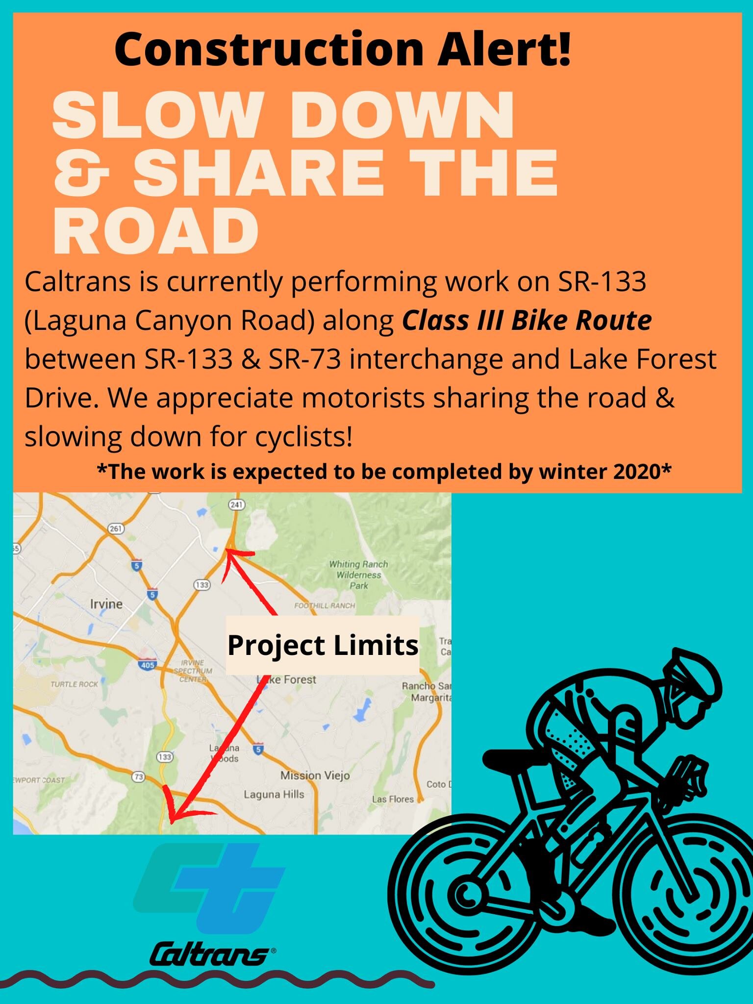
Laguna Canyon Construction Alert

Canyon Update; October 4th Caltrans tells us the concrete K-Rails are all gone from the shoulder.. we will verify ASAP!
November 26th 2021. After 15 months, MOST of the shoulders are open to ride again. Southbound is clear now all the way to the interchange with the 73 Toll Road and the Lake Forest/Moulton/El Toro detour has been removed. Northbound there are still a few long stretches of blocked shoulder where guard railwork continues.

CAUTION TAPE.png
Construction Alert.jpg

If you have not ridden the ‘Canyon’ for a while, expect some surprises between Lake Forest and the 73 Toll Road.
LAST AUGUST (2020) Caltrans placed concrete K-Rails at 22 sections of the shoulder where they are installing guard rails... forcing cyclists to merge into the high speed #2 lane up to 10 times on the way to Laguna & 12 times coming back… There are still (April) 6 SB and 2 or 3 NB in the way.

They gently remind motorists to share the road with us in this Construction Alert:

They posted it with this “#CommuterAlert Friendly reminder to slow down & share the road! Ongoing construction between SR-133 and SR-73 along Class III Bike Route. #caltransoc #slowfortheconezone

Laguna Canyon Road is a State Highway 133 from the end of the freeway in Irvine to the City of Laguna Beach. It is signed and designated as a Class III BIKE ROUTE & has wide paved shoulders (NOT Class II BIKE LANES) between Lake Forest and the 73 Toll Road. Cyclists are allowed to ride in the lane but usually choose to use the shoulder for obvious reasons. Unlike a mandatory use Bike Lane, a shoulder is not legally required.
OCBC has been in communication with Caltrans to try to improve things - the 22 sections where K-Rail barriers have been placed completely block the shoulder. They were placed to protect workers installing guard rails at the edge of the shoulder when working, but have put cyclists in great danger 24/7.
Use EXTREME CAUTION to merge out & share the travel lane around these 'pinch points'. Traffic on Laguna Canyon rarely obeys the posted high speed limit.
Caltrans has promised OCBC that they will remove each segment of K Rail as soon as work is completed at that spot rather than waiting until the last work is complete.
They also promised to push the K-Rail in a foot or two and wire an extension to use the signal button from SB 133 to EB Lake Forest, but that has not been done as of Mid-November. The project schedule puts these in place until WINTER 2021.
After that it will get worse when they work on the segment between the 73 Toll Road and El Toro Road.
At that time expect a full Closure & DETOUR onto EL Toro Road, Moulton and Lake Forest to get around the work zone.

Here is a better view of the current project area:

SR133 Project 9-12_2020.png

What the Caltrans alert asks, but does not convey - it is the responsibility of motorists to change lanes or slow down to pass us with a 3 foot minimum distance; If you have to go between Laguna and Irvine, expect these pinch points and use extreme caution or choose the longer way around the 'canyon' on El Toro Road (only adds 2.5 miles to avoid the 3.6 mile project zone).
SB Detour: https://ridewithgps.com/routes/34389510
NB Detour: https://ridewithgps.com/routes/34389593

133 Detour.png

OCBC has been constantly asking Caltrans what is taking so long to get this Class III bike route safely open… let Bill know if you see anything change ( for the better or worse!)

CAUTION TAPE.png

Regional Parks Connector Bikeway (Resolved)

Temporary closure of the Mountains to the Sea bikeway at Upper Newport Bay: March 2 to ?...
OCBC just got word from OC Parks that this weekend and into next week -rain permitting- the San Diego Creek Multi-Use path will be closed for repairs of flood damage under Jamboree Road. This heavily traveled segment of the Regional Parks Connector Bikeway from Newport to Irvine Regional Park is the down stream end of Peters Canyon Wash where it runs into the bay. It connects to the Bayview Trail along Jamboree. 
The detour OCBC recommend for side walk / bike path preferring cyclists being forced off the Class I bikeway around the closure is the side walks on University between Jamboree and the Bonita Creek path. 
BCI Road using and Edge riders will find cross walks to the Class II Bike Lanes on University. The Bayview side path (along the west side of Jamboree) should be open, pending occasional activity moving in supplies and equipment. Road Closed signs will be in place, it is unknown if a detour will be posted for this short closure.

SD Creek Closure Mar2019.png

Camp Pendleton Access

BASE “DOD Bike Pass” Required

Beginning October 1, 2018, all cyclists who wish to access the cycling route at Camp Pendleton are required to register with the new Department of Defense Biometric Identification System before they enter the base. 
To register for a DBIDS bicycle pass, individuals need to go to the Main/Vandegrift Boulevard visitors center (Oceanside gate) and are required to show an acceptable identity source document such as a valid government issued photo ID (I.E. Real ID ACT compliant driver's license, state identification card, or passport) to establish their identity and submit to a criminal background check as well as having their photograph and fingerprint taken. 
The visitor's center hours are Monday to Friday, from 7:30 a.m. to 3:30 p.m.
Bicycle passes will be valid for one year and will be restricted to bicycle access; any attempt to enter the base in a motor vehicle with a bike pass will be turned around. Recreational cyclists may not sponsor another adult cyclist. Adult cyclists may be accompanied by minors for whom they are directly responsible. 
The cycling route through Camp Pendleton has not changed [North/South from the Las Pulgas gate to the Main gate (Stuart Mesa Rd to Vandergrift Blvd) and South/North from the Main gate to the Las Pulgas gate (Vandergrift Blvd to Stuart Mesa Rd)] and access via the DBIDS bicycle pass is limited to the Main and Las Pulgas gates. 
MCB Camp Pendleton will continue to foster positive relationships with our neighbors by allowing access to cyclists and we appreciate that most cyclists have been good visitors during their time on the base. We encourage cyclists who wish to enjoy uninterrupted access to the base to come in as soon as possible to obtain their DBIDS ID. We anticipate that the volume of passes issued in late September and early October will require long waits, so don't procrastinate. 
The new system will increase installation security and communications by receiving frequent database updates on changes to personnel/credential status, law enforcement warrants, lost/stolen cards, and force protection conditions. The system provides a continuous vetting anytime the DBIDS card is scanned at an installation entry point.
On-line registration of recreational cyclists will end 22 July, 2018. No matter when you registered under the old system, that form of access to the base will end on September 30. After that date only a DBIDS bicycle pass holder will be allowed aboard the base. 
For questions regarding base access, please call 760-763-8435.

Seal_of_Marine_Corps_Base_Camp_Pendleton.png

The USMC have advised the cycling community that failure to obey their single file riding rule and leaving the designated route from Las Pulgas gate to the Main Gate may jeopardize continued access to non-military cyclists.
CalTrans has made the shoulders wide along the 5 Freeway and as there is no other way to get from LAs Pulgas to Oceanside, it is legal to ride on the freeway shoulder if the base is closed to you...
Remember also to renew your on line registration to ride through the base; the USMC has s system in place to register you in advance for one year.  If not registered you may be turned away at the gate to experience the freeway shoulder.

University Dr. from MacArthur to Campus (Resolved)

The work is finally done expanding to 3 travel lanes and a bike lane on University Drive.
Initially work began 2 years ago and there were no detour signs posted as the bike lanes were completely closed off with no shoulder. Eventually there was a posted detour to use the Class I bikeway (San Diego Creek / Peters Canyon / Regional Parks Connector / Mountains to the Sea ‘Trail’) to avoid riding on University while the Class II bike lanes were gone. It is legal to ride a travel lane, but too narrow to share on the edge, and very stressful to control the right lane when so many motorist want us to get out of their way. It was recommended that you use the San Diego Creek bikeway instead - just know it is posted 10 MPH and a multi-use path so it is full of other users.  Southbound you may want to get on near the NW corner of Harvard & University. There are access points at Campus, Mesa, California and the off ramp from the 73, (as well as our usual NW corner of Eastbluff & Jamboree farther west)

University Drive Detour.png

Update: October 2020 - Work is almost complete and the Bike Lanes & fresh pavement are open.

McFadden Bridge to be closed/demolished

CONSTRUCTION UPDATE!

As part of the I-405 Improvement Project, the McFadden Ave. bridge will be closed for full demolition as early as August 7, 2018 at 10 p.m. The bridge will be closed for approximately 12 months for reconstruction. Vehicles, bicycles and pedestrians will not be able to use the bridge during reconstruction.

Detours
Eastbound Routes (EB) 
* EB McFadden Ave. to NB Goldenwest St. to NB Bolsa Ave. to SB Beach Blvd.
* EB McFadden Ave. to SB Goldenwest St. to EB Edinger Ave. to NB Beach Blvd.

Westbound Routes (WB) 
* WB McFadden Ave. to NB Beach Blvd. to WB Bolsa Ave. to SB Goldenwest St.
* WB McFadden Ave. to SB Beach Blvd. to WB Edinger Ave. to NB Goldenwest St.

For information on the projects current activities, closures and detours please visit our interactive map by visiting: www.octa.net/405map

405 Construction Begins

OCTA is starting a 405 freeway widening project that will run from Costa Mesa to the 605 in Seal Beach.  Some of the bridges we use to cross the 405 (e.g. Ward, Talbert) are set to be rebuilt and may be closed entirely during construction.  Please email roads@bikeirvine.org if you notice any closures.  Your humble ride coordinator lives in South OC, so I may not be aware of when these closures start and their impact on our routes. 

Santa Ana River Trail Closure (Resolved)

The County will be closing a major portion of the Santa Ana River to all public access around January 22nd. All current residents are being moved out into other neighborhoods, and the remaining trash and pollution will need to safely be removed, and landscape restored.  The Trail between Memory Lane and Ball/Taft will be closed until the summer of 2018.
We expect the County to post a detour, but unless they re-open the existing paved detour on the east bank between Memory Lane and Orangewood to get past the 22 & 5 freeways, the best on-street detour will likely go west on Memory Lane to Lewis, then north to Orangewood, then east back across the river to Eckhoff, then north to Collins, east to Main, and west on Taft to resume the off street bike path north of Taft.

Proposed detour reopening the existing east bank path: The County has not yet announced their detour plan...

Proposed detour reopening the existing east bank path:
The County has not yet announced their detour plan...

Great Park closed the perimeter road to public

Unfortunately the powers-that-be who are developing former MCAS El Toro into the Great Park have closed the old Perimeter Road to bicycles.  This road runs along the south and east sides of the base.  This eliminates the connection from Marine Way to Astor and Fairbanks in the East Irvine Industrial Complex which we enjoyed during the summer & fall of 2017.

Riders can still enter the area on Marine Way off Sand Canyon, but will have to turn left up either Ridge Valley or Sky Hawk/Bosque to Irvine Blvd.  Bummer, especially for those of us who live in Lake Forest ! 

Photo by Jim Norman 11-4-17

Photo by Jim Norman 11-4-17

Bay View Trail Closed Thru 9/15/17

10/1/17 update - the Trail is open again

OC Public Works will begin repairs on the Bay View Bridge at Upper Newport Bay located within the City of Newport Beach. Portions of the Brown/Bay View trail will be temporarily closed from July 31 to Sept. 15, 2017 for construction activities. 

This is the trail that crosses the back bay between Jamboree and Irvine Ave.   You can detour along Mesa Dr. just to the north.  Here is a map of the detour.


Santa Ana River Trail - Homeless Situation

Due to our winter rains and a construction project, homeless persons camping in the riverbed and along the east side of the river in the Orange/Anaheim area have moved alongside (and in come cases into) the bike trail.

The area most impacted is between the 5 freeway and Katella, along Anaheim Stadium.  In online forums cyclists are reporting confrontations with the homeless in this area.  You may want to consider alternate routes.