


Ride Start: Riverside - La Sierra Station
Route Options:
2 ways out (A or B) x 3 ways back ( 1, 2 or 3) = 6 options:
Routes Slips on 2 pages:
Option A: Around Lake Mathews to Tom’s Farms 13.6 +727/-403 ft
https://ridewithgps.com/routes/38813434
Option B: UP to Lake to Tom’s Farms 12.9 +1,078/-754 ft
https://ridewithgps.com/routes/38813379
Option 1: Tom’s Farms to Anaheim the EASY way 32.7 +536/-1,441 ft
https://ridewithgps.com/routes/38813596
Option 2: Tom’s Farms to Anaheim the HARD way 32.4 +1,308/-2,215 ft
https://ridewithgps.com/routes/38813661
Option 3: Tom’s Farms to Corona West 13.1 +235/-712 ft
https://ridewithgps.com/routes/38813181
If not sure which of the options you want to do -
print both pages of routes & bring them along;
we will have time on the train to see who wants to do what before starting at La Sierra… (A or B)
and again before leaving Tom’s Farms (1, 2 or 3)

Catch the IE/OC Line train #800 to Riverside-La Sierra. It stops at LN/MV, Irvine. Tustin, Santa Ana, Orange & Anaheim Canyon. (NOT ANAHEIM) No Service from San Clemente or San Juan due to track closure. Arrives at LA SIERRA at 9:27. Get a 1 way ticket & if qualified get 1/2 price.
Their Mobile App works better than ticket machines at the stations so load it & set it up before Friday morning…
Arrive at La Sierra - South Riverside at 9:34
The Hardest route will ride UP La Sierra past lake Mathews and drop into Temescal Canyon down Cajalco Road then head south to Tom’s Farms near Glen Ivy for some food… the Less Hilly will go farther AROUND the lake to Temescal Canyon…
After brunch we will head back down Temescal and cross UPPER Corona to the SART back downstream to the Anaheim ARTIC station.
6 OPTIONS: “Most of the ride is downhill or flat…”
A (13.6) or B (12.9) out to Tom’s, 1 ,2 or 3 back to a train
A1 • Less Hilly 46.2 miles +1,270 ft
A2 • Easy out - Hard return 46 miles +2,035 ft
A3 • Short Cut 26.7 miles +968 ft
B1 • Hard out & Hard return 45.6 miles +1,771 ft
B2 • HILLY 45.6 miles +2,367 ft of climb
B3 • Harder Shortest 26 miles +1,313 ft
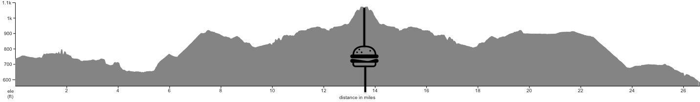
Option B2: Lake Mathews Ride to Anaheim -
Hardest to Tom’s & Hardest to Anaheim
45.3 miles then train back home…
Map/Elevation (the Long & Hilly way)


Option A1: Skips Lake Mathews and upper Corona’s hills…
Flattest Ride to Anaheim -
46.3 miles then train back home…
Map/Elevation
(the SLIGHTLY Longer but MUCH Flatter & Less Scenic way)

From Anaheim there are several trains back toward Irvine on the OC Line. (600’s)
#682 @ 2:55, #600 @ 4:11, #684 @ 4:35, #602 @ 5:15, #686 @ 5:31, #604@6:26
& #688 @ 715 (LAST TRAIN)


Option A3: Short Cut
skips climbs to Lake Mathews
26.6 miles +968 ft / -1,122 ft
Option B3: Harder Short Cut
climbs to Lake Mathews on way out
26 miles +1,301 ft / -1,454 ft
Both catch the 815 or 817 trains
from Corona West
IEOC Line trains (800’s) do not stop at Anaheim, but they do the same stops all the way from Orange on. #815 @ 1:44, #8:17 @ 3:13 (LAST TRAIN)
Map/Elevation (26.6 mile easier short cut - Option A3)

Map/Elevation (26 mile harder & shortest - Option B3)