Camp Pendleton Access

BASE “DOD Bike Pass” Required

Beginning October 1, 2018, all cyclists who wish to access the cycling route at Camp Pendleton are required to register with the new Department of Defense Biometric Identification System before they enter the base. 
To register for a DBIDS bicycle pass, individuals need to go to the Main/Vandegrift Boulevard visitors center (Oceanside gate) and are required to show an acceptable identity source document such as a valid government issued photo ID (I.E. Real ID ACT compliant driver's license, state identification card, or passport) to establish their identity and submit to a criminal background check as well as having their photograph and fingerprint taken. 
The visitor's center hours are Monday to Friday, from 7:30 a.m. to 3:30 p.m.
Bicycle passes will be valid for one year and will be restricted to bicycle access; any attempt to enter the base in a motor vehicle with a bike pass will be turned around. Recreational cyclists may not sponsor another adult cyclist. Adult cyclists may be accompanied by minors for whom they are directly responsible. 
The cycling route through Camp Pendleton has not changed [North/South from the Las Pulgas gate to the Main gate (Stuart Mesa Rd to Vandergrift Blvd) and South/North from the Main gate to the Las Pulgas gate (Vandergrift Blvd to Stuart Mesa Rd)] and access via the DBIDS bicycle pass is limited to the Main and Las Pulgas gates. 
MCB Camp Pendleton will continue to foster positive relationships with our neighbors by allowing access to cyclists and we appreciate that most cyclists have been good visitors during their time on the base. We encourage cyclists who wish to enjoy uninterrupted access to the base to come in as soon as possible to obtain their DBIDS ID. We anticipate that the volume of passes issued in late September and early October will require long waits, so don't procrastinate. 
The new system will increase installation security and communications by receiving frequent database updates on changes to personnel/credential status, law enforcement warrants, lost/stolen cards, and force protection conditions. The system provides a continuous vetting anytime the DBIDS card is scanned at an installation entry point.
On-line registration of recreational cyclists will end 22 July, 2018. No matter when you registered under the old system, that form of access to the base will end on September 30. After that date only a DBIDS bicycle pass holder will be allowed aboard the base. 
For questions regarding base access, please call 760-763-8435.

Seal_of_Marine_Corps_Base_Camp_Pendleton.png

The USMC have advised the cycling community that failure to obey their single file riding rule and leaving the designated route from Las Pulgas gate to the Main Gate may jeopardize continued access to non-military cyclists.
CalTrans has made the shoulders wide along the 5 Freeway and as there is no other way to get from LAs Pulgas to Oceanside, it is legal to ride on the freeway shoulder if the base is closed to you...
Remember also to renew your on line registration to ride through the base; the USMC has s system in place to register you in advance for one year.  If not registered you may be turned away at the gate to experience the freeway shoulder.

University Dr. from MacArthur to Campus (Resolved)

The work is finally done expanding to 3 travel lanes and a bike lane on University Drive.
Initially work began 2 years ago and there were no detour signs posted as the bike lanes were completely closed off with no shoulder. Eventually there was a posted detour to use the Class I bikeway (San Diego Creek / Peters Canyon / Regional Parks Connector / Mountains to the Sea ‘Trail’) to avoid riding on University while the Class II bike lanes were gone. It is legal to ride a travel lane, but too narrow to share on the edge, and very stressful to control the right lane when so many motorist want us to get out of their way. It was recommended that you use the San Diego Creek bikeway instead - just know it is posted 10 MPH and a multi-use path so it is full of other users.  Southbound you may want to get on near the NW corner of Harvard & University. There are access points at Campus, Mesa, California and the off ramp from the 73, (as well as our usual NW corner of Eastbluff & Jamboree farther west)

University Drive Detour.png

Update: October 2020 - Work is almost complete and the Bike Lanes & fresh pavement are open.

McFadden Bridge to be closed/demolished

CONSTRUCTION UPDATE!

As part of the I-405 Improvement Project, the McFadden Ave. bridge will be closed for full demolition as early as August 7, 2018 at 10 p.m. The bridge will be closed for approximately 12 months for reconstruction. Vehicles, bicycles and pedestrians will not be able to use the bridge during reconstruction.

Detours
Eastbound Routes (EB) 
* EB McFadden Ave. to NB Goldenwest St. to NB Bolsa Ave. to SB Beach Blvd.
* EB McFadden Ave. to SB Goldenwest St. to EB Edinger Ave. to NB Beach Blvd.

Westbound Routes (WB) 
* WB McFadden Ave. to NB Beach Blvd. to WB Bolsa Ave. to SB Goldenwest St.
* WB McFadden Ave. to SB Beach Blvd. to WB Edinger Ave. to NB Goldenwest St.

For information on the projects current activities, closures and detours please visit our interactive map by visiting: www.octa.net/405map

405 Construction Begins

OCTA is starting a 405 freeway widening project that will run from Costa Mesa to the 605 in Seal Beach.  Some of the bridges we use to cross the 405 (e.g. Ward, Talbert) are set to be rebuilt and may be closed entirely during construction.  Please email roads@bikeirvine.org if you notice any closures.  Your humble ride coordinator lives in South OC, so I may not be aware of when these closures start and their impact on our routes. 

Santa Ana River Trail Closure (Resolved)

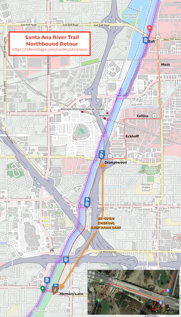
The County will be closing a major portion of the Santa Ana River to all public access around January 22nd. All current residents are being moved out into other neighborhoods, and the remaining trash and pollution will need to safely be removed, and landscape restored.  The Trail between Memory Lane and Ball/Taft will be closed until the summer of 2018.
We expect the County to post a detour, but unless they re-open the existing paved detour on the east bank between Memory Lane and Orangewood to get past the 22 & 5 freeways, the best on-street detour will likely go west on Memory Lane to Lewis, then north to Orangewood, then east back across the river to Eckhoff, then north to Collins, east to Main, and west on Taft to resume the off street bike path north of Taft.

Proposed detour reopening the existing east bank path: The County has not yet announced their detour plan...

Proposed detour reopening the existing east bank path:
The County has not yet announced their detour plan...

Great Park closed the perimeter road to public

Unfortunately the powers-that-be who are developing former MCAS El Toro into the Great Park have closed the old Perimeter Road to bicycles.  This road runs along the south and east sides of the base.  This eliminates the connection from Marine Way to Astor and Fairbanks in the East Irvine Industrial Complex which we enjoyed during the summer & fall of 2017.

Riders can still enter the area on Marine Way off Sand Canyon, but will have to turn left up either Ridge Valley or Sky Hawk/Bosque to Irvine Blvd.  Bummer, especially for those of us who live in Lake Forest ! 

Photo by Jim Norman 11-4-17

Photo by Jim Norman 11-4-17

Bay View Trail Closed Thru 9/15/17

10/1/17 update - the Trail is open again

OC Public Works will begin repairs on the Bay View Bridge at Upper Newport Bay located within the City of Newport Beach. Portions of the Brown/Bay View trail will be temporarily closed from July 31 to Sept. 15, 2017 for construction activities. 

This is the trail that crosses the back bay between Jamboree and Irvine Ave.   You can detour along Mesa Dr. just to the north.  Here is a map of the detour.


Santa Ana River Trail - Homeless Situation

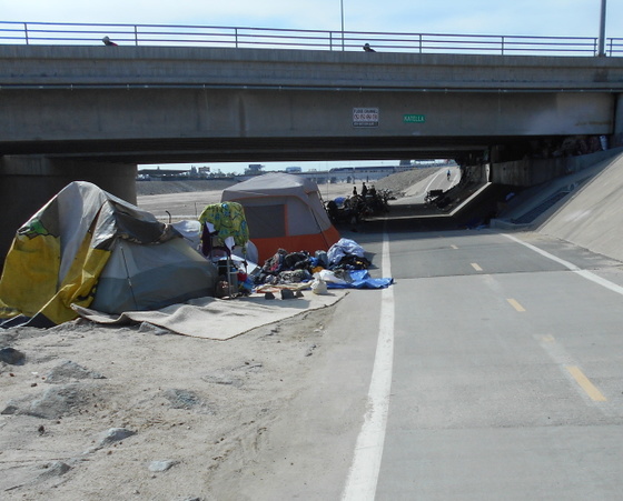
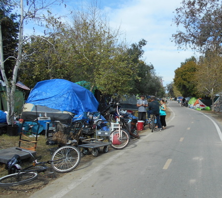
Due to our winter rains and a construction project, homeless persons camping in the riverbed and along the east side of the river in the Orange/Anaheim area have moved alongside (and in come cases into) the bike trail.

The area most impacted is between the 5 freeway and Katella, along Anaheim Stadium.  In online forums cyclists are reporting confrontations with the homeless in this area.  You may want to consider alternate routes. 

Construction near Santiago Canyon Road/Jamboree/241

Irvine Ranch Water District is converting the northern segment of its Irvine Lake Pipeline to recycled water. During the months of December and January, contractor trucks will be utilizing E. Santiago Canyon Road near Jamboree and the 241 Toll Road to transport dirt and materials. Traffic delays may be possible on Santiago Canyon Road during peak traffic hours. For more information, please visit http://www.irwd.com/construction/ilp-con...

Red Hill Ave. - Bridge over 405 closed to all traffic.

Red Hill is closed to all traffic over the 405 for repairs to the bridge and surrounding structure.  Bikes cannot get through.   Current information from the cities say that it will be closed through December 2016 with off-and-on closures into 2017.  

Because this is between the 55 freeway and John Wayne Airport there are no good bike-friendly detours nearby.  Your best bet is to modify your route to go east of the airport using Irvine Avenue/Campus and Von Karman.

Santa Ana River Bikeway Detour

There is a detour in effect for the SART about midway between Weir Canyon Road and Gypsum Canyon Road. Riders will need to exit the trail and ride along La Palma in this area. This detour is expected to be in place until December 2017. This sign will be installed by the Army Corps of Engineer’s contractor at entrances to the detour:

The good news is the trail between Lakeview and Tustin is now open, it is no longer necessary to detour on Riverdale. 

Jim Norman

San Diego Creek Trail bikeway at Spectrum

The San Diego Creek Trail extends from the Upper Newport Bay upstream to the Irvine Meadows Amphitheater. Up stream from going under the 133 Laguna Freeway, the route crosses the creek on a side path of the Spectrum road bridge, then continues along the creek under the 405 Freeway.  This bridge has been closed to traffic and cyclist usually crossed in the road, but now is full of parked and moving construction vehicles so share the road.  The side path - the wide side walk intended for trail users - has a temporary water pipe right across the path from the fire hydrant. This is a temporary supply but services the water fro the new construction yard at the end of Spectrum road... but may be a trip hazard for a long time. Also there are no painted crosswalks so watch out for traffic now when continuing on the trail across Spectrum, or crossing the road to use the connector to Pacifica.      

Bill Sellin


Alton from Technology to Barranca in East Irvine

Alton has been narrowed in both directions during construction between to Barranca / Muirlands and Technology. There is a speed reduction, but the bike lane has been narrowed, contained within concrete barriers and the pavement is pretty rough; and as the travel lanes are wearing down, gravel & such is spreading into the bike lanes. Watch for vehicles turning right across your path of travel where the bike lane ends at Muirlands.

Bill Sellin